Saturday, May 13, 2006
to troy and back again: fixed-gear adventures in long cane country

I don't think I'd ever been to Troy, SC before today. If I drove through there, it was a long time ago and I wasn't paying attention. Riding in cars is like that.
I had, however, been looking at Troy on the map for several weeks. I'd used the Windows box computer on my desk to check out the county's GIS site (which doesn't work on my beloved PowerBook, dang it!), comparing the road names to the lines on my pasted-together photocopied maps of the area. I'd figured out a route weeks ago and had discussed it with Ainsley, but there just wasn't a good time - until today.
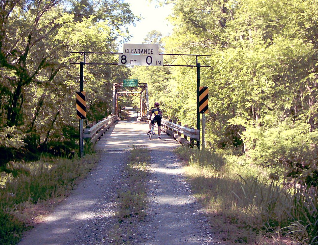
We met at the fountain early, shooting for 8:00. As Ainsley put it, "If I can get to work there at 8:00, I ought to be able to get there for a ride." I wound up being seven minutes late, but Ainsley was still setting up equipment, so it was all right. We got rolling at 8:14, going out the usual rail-trail to Wisewood to West Scotch Cross to Rock House Road. We were on the last bit of Rock House in the area I call the Greenwood Steppes when we saw something slink across the road and into the brush. As we passed the clearing we both caught a glimpse of something dark and moderately large getting out of sight.
"What was that?" I said.
"Maybe it was the Abbeville Panther," Ainsley suggested, reminding me of a recent and overblown newspaper story.
We talked about it for the rest of Rock House and I agreed with Ainsley that it was probably what he called a "melanistic bobcat." Something large and vaguely predatory could live in that area for a long time dining on some of the zillions of rabbits that surely lived there - like the three we saw in short order. We made the turn and crossed the bridge and turned left onto Millpond. As we did a couple of weeks back, we commented on how much smoother its dirt surface was compared to the bumpy macadam of Rock House.
We stopped at the entrance to Calabash Road to eat small snacks and check the map out again, a process we would repeat frequently as the day wore on. I had 18 miles and change at that point. I led off and we began to learn another road.
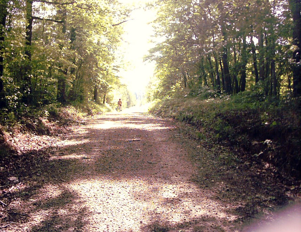
Calabash looks like a regular dirt road for the area, but then you come to a fork. The left fork, which is maintained like the entry section, is somebody's driveway. The right fork, which we took, doesn't appear to be maintained much, if at all. The surface was sort of a cross between sand and tiny pebbles - standing climbing was an experience. The tiny one-lane bridge we crossed looked like an afterth ought, thrown together with odd leftover bits from the highway department. But it was just so danged pretty back there. I took a couple of pictures that mostly showed how shady the woods were, and then we were riding on tar and pea gravel for a couple hundred yards - not paved, just kinda dumped in a there-ya-go fashion right onto the dirt.
Time to consult the map again - our route lay to the right along Highway 221. Right beyond the first bend was a dirt road - no name on the map, no sign, just a nameless dirt road next to a church, and we followed it to Highway 10. Once across, we found ourselves on Barksdale Ferry Road. Now, we could have just ridden 10 into Troy - there's not much traffic on it at that point - but here was a perfectly good dirt road on a pleasant day. So down Barksdale Ferry we went, passing a beautiful 19th Century house hidden by the woods from the world, down a long hill and working our way South by Southwest.
We emerged on pavement where Cox Road leads off to the right - a turn we should have made, according to the route I had planned.
"Seems kinda wrong to ride to Troy without actually seeing what's there," I told Ainsley.
"Not much there," he said.
I pondered our low food s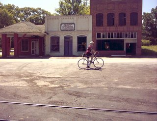 upply - we had one granola bar between us at this point - and asked, "Any convenience stores?"
"There's a Mom and Pop place like the one in Bradley, I think."
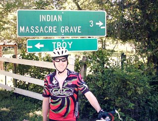
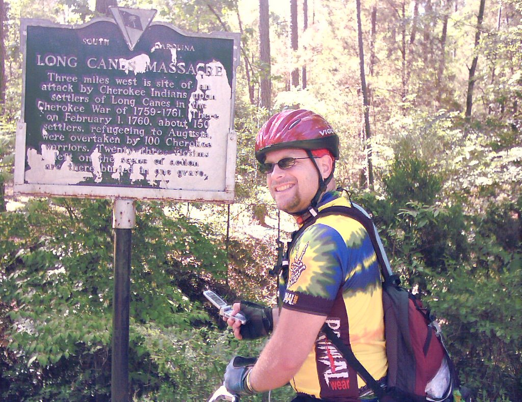
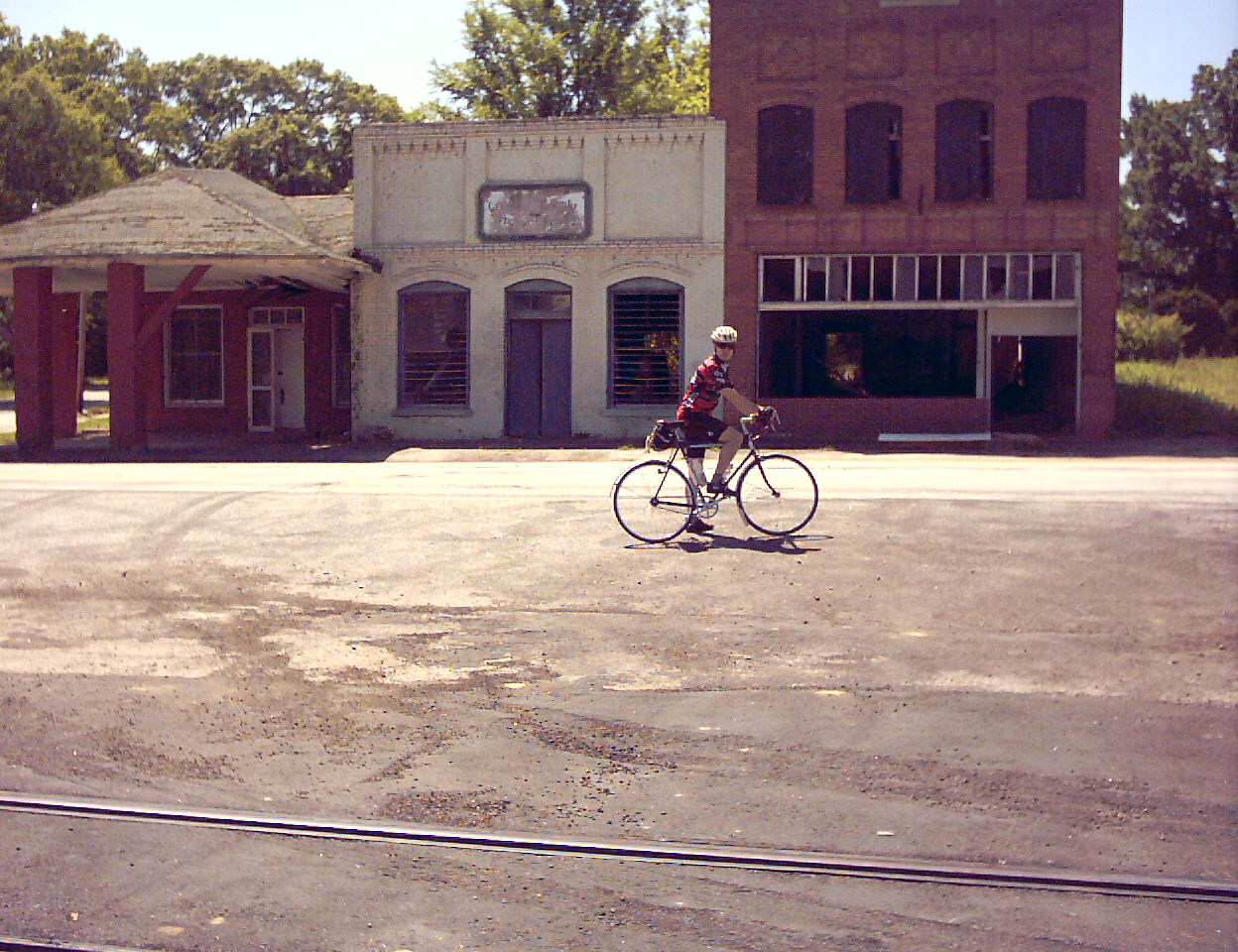
So we rode on to Troy. The Mom and Pop place turned out to be a restaurant called the Hash House that was just setting up for the day - we passed on that. There was a clump of abandoned buildings along the highway and a small, neatly painted town hall. After consulting the map again, we made the turn onto Greenwood Street - and then Ainsley saw the sign for the Indian Massacre Grave Site.
The Long Cane Massacre is something I've seen references to since I first lived here in 1981. On February 1, 1760, 23 settlers were killed by Cherokee Indians while attempting to flee to safety from an impending attack. It was apparently a powerful, formative experience for the Scottish Presbyterians of the area, and there are references to it all over the place.
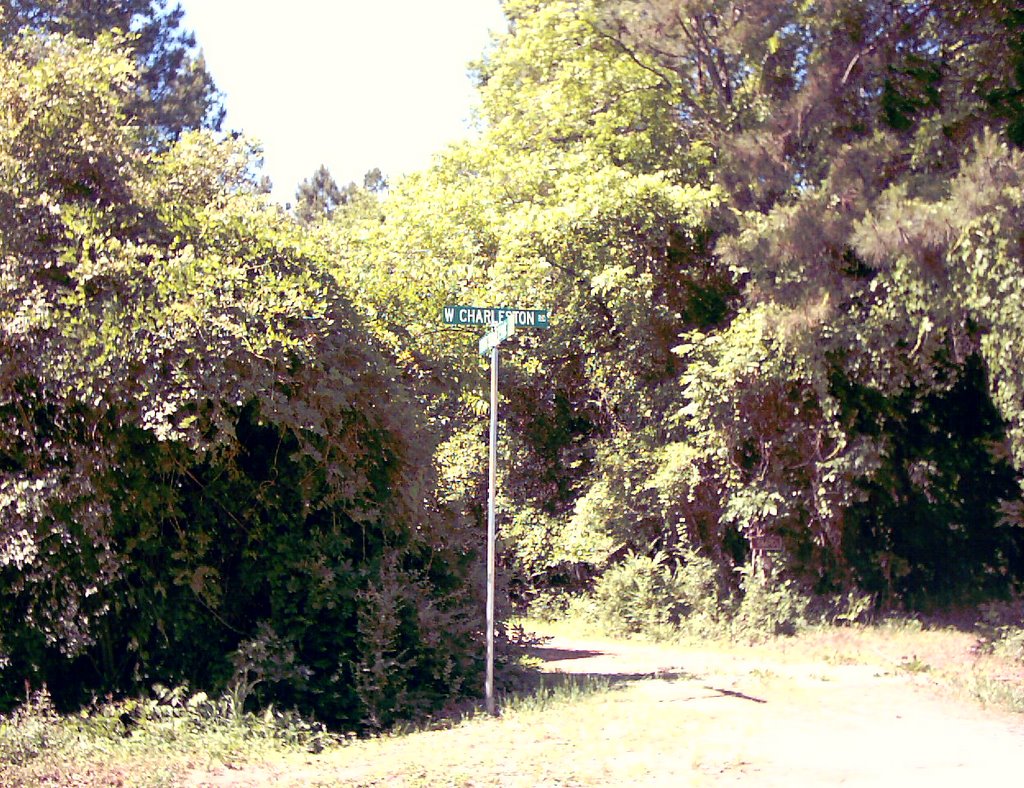
Ainsley wanted to go check it out, and the sign said 3 miles, so I figured, why not? We turned and followed the signs, eventually coming to West Charleston Road. After a bit, it turned to dirt road, but that's what we were looking for, right?
West Charleston Road is a delight for the dirt-riding roadie - some whoop de doos, a couple of hills, but generally a decent surface. We came to the turn off to the gravesite and went down the steep hill. I read the marker, then dismounted and followed Ainsley across the footbridge. There were two markers and a foot stone; the older marker was for Catherine Calhoun and appeared to be roughly contemporary to her death, while the other was much newer and had been placed in honor of five casualties by a descendant.
"It's kind of surreal," Ainsley said. "This gravesite is more than 200 years old, but it's still maintained."
It was strange. This place was in the middle of nowhere, but the grass was cut, and two small trellises supported rose bushes. We talked about how this had probably been part of an open field until relatively recently - there were no hardwoods, and all the pines looked to be 50 years old or younger. Putting our helmets back on, we went back across the bridge and got up the hill with less effort than we feared.
West Charleston really came into its own now, complete with a really cool steel and wood bridge over Long Cane Creek. We surprised a buzzard and a turkey with our voices. After taking a couple of photos, I rolled across what felt like 2x4s set edgewise, and the rumble of my tires set two Mallards that had been swimming below into flight.
A couple of miles later we hit pavement and found ourselves looking at Ivy Hall, aka the Wideman Plantation. At least, that's what the sign said. The directional signs indicated that going right would take us to Troy in two miles. Hmm. Another map check, and we agreed that if we went right, we'd come to a T that would take us on out to our original route. We rode for several miles, being passed by the occasional pickup truck or sensible sedan, and finally reached a T intersection - only to find ourselves back in Troy.
We rode back to the town center, such as it was, and pondered the map again before finding our error. Back out the way we'd just come, but this time we stayed straight, eventually hitting Puckett Town Road. I felt better seeing the sign - it was the right direction after all. A while later, I looked ahead and saw a "pavement ends" sign. Actually, Puckett Town peeled off to the right, but our route lay straight ahead.
I've been curious about Sumter Forest Road ever since I first saw it on the GIS site. It turned out to be one of the best dirt roads yet. It was smooth, apart fro m the first few yards it was pretty well hard packed, and had only one descent that required steady back pressure against the fixed-gear's lockringed cog, followed by a dainty bridge, then one grunt of a climb. I slogged up the hill standing, feeling Julius' back end fishtail on some loose stuff.
At the top, Ainsley shook his head. "That was special."
"Wasn't it just," I said.
Fortunately, from that point on, Sumter Forest is pretty much flat and smooth hardpack all the way to Cedar Springs. We stopped for yet another breather, but for once left the map in my saddlebag. We knew where we were.
"Wanna split this last granola bar?" Ainsley said.
I took him up on his offer. "Let's go in via Promised Land," I said. "We can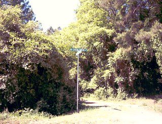 resupply at the store there. For once, I actually have a couple of dollars in my wallet."
He was agreeable to that idea, so we set off down Cedar Springs Road, passing the church there (I think it was the fifth or sixth Associate Reformed Presbyterian Church I'd passed since Troy) and going down the bumpy tarmac towards Highway 10. We had the wind at our backs, which made life much easier. By this point my legs were a little tired, my hands and feet were numb from the road vibration, and my butt wanted to be somewhere other than on a Brooks B17 saddle.
It was worse for Ainsley. He'd ridden the beater Schwinn with its wretched cheap saddle, and he proclaimed he would soon be acquiring something a bit more comfortable.
The Promised Land Grocery Store was an experience. Vehicles were parked haphazardly in the lot, and people milled back and forth in and out of the place. Ainsley stayed with the bikes while I went in and got some food and a bottle of water. We munched and drank standing in the shade outside the storefront, watching cautiously while a guy filled a gascan with his right hand while holding a lit cigarette in his left. I thought about the movie Zoolander and wondered how fast I could move if things went boom suddenly.
Then we were off again, rolling down W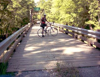 hitehall to Briarwood. I felt like I had a second wind, and I was able to turn the 45x18 with a little more crispness, feeling the spin in my legs and keeping my heels dropped for better speed. The winds were favorable, and the sudden shift to smooth pavement from tarmac was pure heaven.
Neither of us was quite sure where West Alexander would deposit us, so we opted for the usual route down Florida Avenue. Ainsley was truly suffering now.
"I'm looking forward to the hills so I can stand up," he said. "My legs may be screaming at me, but it's just so good to be off the saddle."
I nodded, grateful that the B17 under me was still on friendly terms. We crossed 221 and rolled up past the deserted little houses near the trail's end. Along the way we overtook an extended family of folks, adults walking, children riding gaily colored high-riser bikes. I pulled ahead on the last rise and decided to take Ainsley down Mineral Court instead of staying with the trail.
The shopping carts were gone. I'd described them to Ainsley earlier in the day, explaining how there had been two standing together next to one on its side.
"You know, when the mating season for feral shopping carts comes along, sometimes the males fight for dominance. It can be brutal, and who knows how many shopping carts meet their end this way," I said.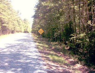
Ainsley allowed that shopping carts in the wild led rough lives. We wondered who had collected them, then we were on Edgefield and heading for the fountain. I gave him mileage stats and said goodbye and headed home, well pleased with myself. It was a slow ride, but I had 61.09 miles by the time I pulled up in my driveway. About 1/4 of that was on dirt roads, many of them new to me, and I'd done it on a fixed-gear. I felt fierce and exultant, if famished. Lunch awaited me. ¶ 9:01 PM

I don't think I'd ever been to Troy, SC before today. If I drove through there, it was a long time ago and I wasn't paying attention. Riding in cars is like that.
I had, however, been looking at Troy on the map for several weeks. I'd used the Windows box computer on my desk to check out the county's GIS site (which doesn't work on my beloved PowerBook, dang it!), comparing the road names to the lines on my pasted-together photocopied maps of the area. I'd figured out a route weeks ago and had discussed it with Ainsley, but there just wasn't a good time - until today.
We met at the fountain early, shooting for 8:00. As Ainsley put it, "If I can get to work there at 8:00, I ought to be able to get there for a ride." I wound up being seven minutes late, but Ainsley was still setting up equipment, so it was all right. We got rolling at 8:14, going out the usual rail-trail to Wisewood to West Scotch Cross to Rock House Road. We were on the last bit of Rock House in the area I call the Greenwood Steppes when we saw something slink across the road and into the brush. As we passed the clearing we both caught a glimpse of something dark and moderately large getting out of sight.
"What was that?" I said.
"Maybe it was the Abbeville Panther," Ainsley suggested, reminding me of a recent and overblown newspaper story.
We talked about it for the rest of Rock House and I agreed with Ainsley that it was probably what he called a "melanistic bobcat." Something large and vaguely predatory could live in that area for a long time dining on some of the zillions of rabbits that surely lived there - like the three we saw in short order. We made the turn and crossed the bridge and turned left onto Millpond. As we did a couple of weeks back, we commented on how much smoother its dirt surface was compared to the bumpy macadam of Rock House.
We stopped at the entrance to Calabash Road to eat small snacks and check the map out again, a process we would repeat frequently as the day wore on. I had 18 miles and change at that point. I led off and we began to learn another road.
Calabash looks like a regular dirt road for the area, but then you come to a fork. The left fork, which is maintained like the entry section, is somebody's driveway. The right fork, which we took, doesn't appear to be maintained much, if at all. The surface was sort of a cross between sand and tiny pebbles - standing climbing was an experience. The tiny one-lane bridge we crossed looked like an afterth
 ought, thrown together with odd leftover bits from the highway department. But it was just so danged pretty back there. I took a couple of pictures that mostly showed how shady the woods were, and then we were riding on tar and pea gravel for a couple hundred yards - not paved, just kinda dumped in a there-ya-go fashion right onto the dirt.
Time to consult the map again - our route lay to the right along Highway 221. Right beyond the first bend was a dirt road - no name on the map, no sign, just a nameless dirt road next to a church, and we followed it to Highway 10. Once across, we found ourselves on Barksdale Ferry Road. Now, we could have just ridden 10 into Troy - there's not much traffic on it at that point - but here was a perfectly good dirt road on a pleasant day. So down Barksdale Ferry we went, passing a beautiful 19th Century house hidden by the woods from the world, down a long hill and working our way South by Southwest.
We emerged on pavement where Cox Road leads off to the right - a turn we should have made, according to the route I had planned.
"Seems kinda wrong to ride to Troy without actually seeing what's there," I told Ainsley.
"Not much there," he said.
I pondered our low food s
 upply - we had one granola bar between us at this point - and asked, "Any convenience stores?"
"There's a Mom and Pop place like the one in Bradley, I think."
So we rode on to Troy. The Mom and Pop place turned out to be a restaurant called the Hash House that was just setting up for the day - we passed on that. There was a clump of abandoned buildings along the highway and a small, neatly painted town hall. After consulting the map again, we made the turn onto Greenwood Street - and then Ainsley saw the sign for the Indian Massacre Grave Site.
The Long Cane Massacre is something I've seen references to since I first lived here in 1981. On February 1, 1760, 23 settlers were killed by Cherokee Indians while attempting to flee to safety from an impending attack. It was apparently a powerful, formative experience for the Scottish Presbyterians of the area, and there are references to it all over the place.
Ainsley wanted to go check it out, and the sign said 3 miles, so I figured, why not? We turned and followed the signs, eventually coming to West Charleston Road. After a bit, it turned to dirt road, but that's what we were looking for, right?
West Charleston Road is a delight for the dirt-riding roadie - some whoop de doos, a couple of hills, but generally a decent surface. We came to the turn off to the gravesite and went down the steep hill. I read the marker, then dismounted and followed Ainsley across the footbridge. There were two markers and a foot stone; the older marker was for Catherine Calhoun and appeared to be roughly contemporary to her death, while the other was much newer and had been placed in honor of five casualties by a descendant.
"It's kind of surreal," Ainsley said. "This gravesite is more than 200 years old, but it's still maintained."
It was strange. This place was in the middle of nowhere, but the grass was cut, and two small trellises supported rose bushes. We talked about how this had probably been part of an open field until relatively recently - there were no hardwoods, and all the pines looked to be 50 years old or younger. Putting our helmets back on, we went back across the bridge and got up the hill with less effort than we feared.

West Charleston really came into its own now, complete with a really cool steel and wood bridge over Long Cane Creek. We surprised a buzzard and a turkey with our voices. After taking a couple of photos, I rolled across what felt like 2x4s set edgewise, and the rumble of my tires set two Mallards that had been swimming below into flight.
A couple of miles later we hit pavement and found ourselves looking at Ivy Hall, aka the Wideman Plantation. At least, that's what the sign said. The directional signs indicated that going right would take us to Troy in two miles. Hmm. Another map check, and we agreed that if we went right, we'd come to a T that would take us on out to our original route. We rode for several miles, being passed by the occasional pickup truck or sensible sedan, and finally reached a T intersection - only to find ourselves back in Troy.
We rode back to the town center, such as it was, and pondered the map again before finding our error. Back out the way we'd just come, but this time we stayed straight, eventually hitting Puckett Town Road. I felt better seeing the sign - it was the right direction after all. A while later, I looked ahead and saw a "pavement ends" sign. Actually, Puckett Town peeled off to the right, but our route lay straight ahead.
I've been curious about Sumter Forest Road ever since I first saw it on the GIS site. It turned out to be one of the best dirt roads yet. It was smooth, apart fro
 m the first few yards it was pretty well hard packed, and had only one descent that required steady back pressure against the fixed-gear's lockringed cog, followed by a dainty bridge, then one grunt of a climb. I slogged up the hill standing, feeling Julius' back end fishtail on some loose stuff.
At the top, Ainsley shook his head. "That was special."
"Wasn't it just," I said.
Fortunately, from that point on, Sumter Forest is pretty much flat and smooth hardpack all the way to Cedar Springs. We stopped for yet another breather, but for once left the map in my saddlebag. We knew where we were.
"Wanna split this last granola bar?" Ainsley said.
I took him up on his offer. "Let's go in via Promised Land," I said. "We can
 resupply at the store there. For once, I actually have a couple of dollars in my wallet."
He was agreeable to that idea, so we set off down Cedar Springs Road, passing the church there (I think it was the fifth or sixth Associate Reformed Presbyterian Church I'd passed since Troy) and going down the bumpy tarmac towards Highway 10. We had the wind at our backs, which made life much easier. By this point my legs were a little tired, my hands and feet were numb from the road vibration, and my butt wanted to be somewhere other than on a Brooks B17 saddle.
It was worse for Ainsley. He'd ridden the beater Schwinn with its wretched cheap saddle, and he proclaimed he would soon be acquiring something a bit more comfortable.
The Promised Land Grocery Store was an experience. Vehicles were parked haphazardly in the lot, and people milled back and forth in and out of the place. Ainsley stayed with the bikes while I went in and got some food and a bottle of water. We munched and drank standing in the shade outside the storefront, watching cautiously while a guy filled a gascan with his right hand while holding a lit cigarette in his left. I thought about the movie Zoolander and wondered how fast I could move if things went boom suddenly.
Then we were off again, rolling down W
 hitehall to Briarwood. I felt like I had a second wind, and I was able to turn the 45x18 with a little more crispness, feeling the spin in my legs and keeping my heels dropped for better speed. The winds were favorable, and the sudden shift to smooth pavement from tarmac was pure heaven.
Neither of us was quite sure where West Alexander would deposit us, so we opted for the usual route down Florida Avenue. Ainsley was truly suffering now.
"I'm looking forward to the hills so I can stand up," he said. "My legs may be screaming at me, but it's just so good to be off the saddle."
I nodded, grateful that the B17 under me was still on friendly terms. We crossed 221 and rolled up past the deserted little houses near the trail's end. Along the way we overtook an extended family of folks, adults walking, children riding gaily colored high-riser bikes. I pulled ahead on the last rise and decided to take Ainsley down Mineral Court instead of staying with the trail.
The shopping carts were gone. I'd described them to Ainsley earlier in the day, explaining how there had been two standing together next to one on its side.
"You know, when the mating season for feral shopping carts comes along, sometimes the males fight for dominance. It can be brutal, and who knows how many shopping carts meet their end this way," I said.

Ainsley allowed that shopping carts in the wild led rough lives. We wondered who had collected them, then we were on Edgefield and heading for the fountain. I gave him mileage stats and said goodbye and headed home, well pleased with myself. It was a slow ride, but I had 61.09 miles by the time I pulled up in my driveway. About 1/4 of that was on dirt roads, many of them new to me, and I'd done it on a fixed-gear. I felt fierce and exultant, if famished. Lunch awaited me. ¶ 9:01 PM
Comments:
<< Home

Better provisions for sure! For that matter, I think this could be part of the much-discussed, still-not-completely-planned Hundred the Hard Way ride. Sooner or later we're going to have to put together a semi-organized ride along these lines - no sags, no rest-stops, but maps, etc. Could be good ...
As it was, it's close to a 100k, but we can go by parson's mnt and maybe to Abbeville for a full English 100mile route.
Post a Comment
<< Home
